SSO, MFA & PAM Documentation
Creating Geo-Location/Fencing and Log-On Event Policies
What is Geo-Location?
Geo-location refers to the latitude and longitude coordinates of a particular location. This could be a location in a remote location, city, state or country. The standards for Real-Time Locating System (RTLS) are ISO/IEC 19762:2016. Real-time locating systems (RTLS) are used to automatically identify and track the location of objects or people in real time. GPS, RFID, Wi-Fi or cellular network tags are attached to objects or worn by people or objects (Tagged Items)] Examples of RTLS include companies are using this technology for sending mobile notifications, trigger text messages or alerts, allow tracking on vehicle fleets, or deliver location-based marketing data.
What is Geo-Fencing?
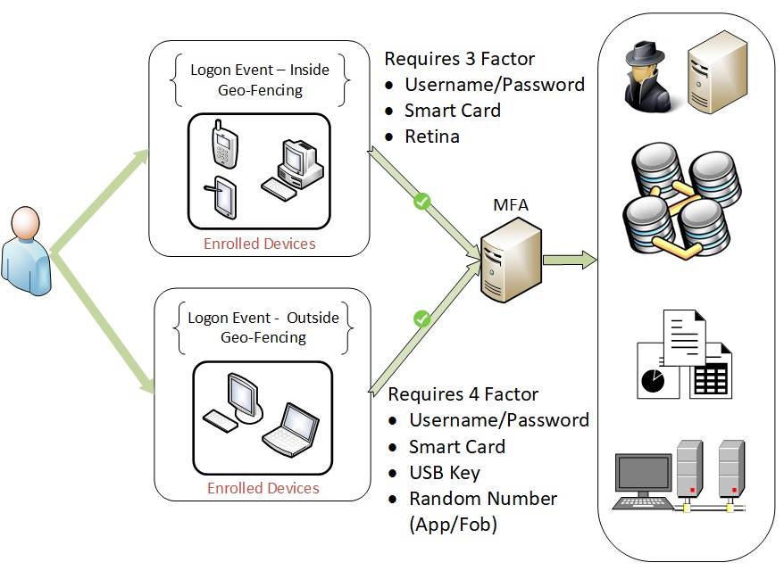
Lets create a Geo-Fence for a location. When you are within the Geo-Fence, we require 3 Factor Authentication and outside 4 Factor Authentication.
Geo-Fencing is a location-based service in which a system or software uses GPS, RFID, Wi-Fi or cellular networks to trigger an event or action. When a device or "Tagged" item enters or exits a virtual boundary (Geo-Fence Location) it will trigger a policy. When entering the virtual location, our policy will seek step up authentication with additional methods being used for log in. When leaving the virtual location, the device or "Tagged" item will be logged out and require to be authenticated once more upon entering the virtual location. This assumes the device or "Tagged" item is still allowed to reenter by our policy. Geo-Fence are used to monitor activity in secure facilities, allowing management to see alerts when anyone enters or leaves a specific area. Not to mention, this also used to keep track of company property no matter where it is located.

